Friday 18 November 2011

What would Harold Say?


 Amid the controversy surrounding the National Planning Policy Framework as way of finding our bearings perhaps it would be worth while casting our minds back to the planning policies of previous Conservative governments. As I have already indicated here, I believe that the planning-free-zone of the 1980s often  led to urban design of a very poor quality. Perhaps if we extend the time frame further, as far back as the 1950s, then we can see examples of urban design which seem relevant today. The fact that the Conservatives won an election in  1951 and the subsequent popularity of that Government has often been attributed to  Harold Macmillan’s grasp of this issue. His willingness to campaign on this issue prior to the  election and the success of his tenure as Minister for Housing from 1951 -1954 where he famously met his target of 300,000 new homes a year, surely holds lessons for our current government. The failure of  the current Conservative Party to appreciate this lesson might explain their failure to secure an outright majority at the last election.

 Reviewing planning policies as they currently stand, the approach to planning of the  last 10-15 years i.e. the Blair years were generally determined by John Prescott. John Prescott’s approach to planning and urban design was basically guided by the report “Towards an Urban Renaissance”,  probably the most influential planning document  during this period. “Towards an Urban Renaissance”  was produced by the Urban Task Force chaired by Richard Rogers so it really was his brainchild. Rogers argues for the polycentric city, that a city should not be seen as a single entity but as a series of villages or neighbourhoods.
 
Much of Roger’s argument revolves around density. This is measured by the acronym DPH  (dwellings per hectare.)  Only when this reaches a critical level is it possible to create a catchment area that can justify local services such as a doctor, bus stop, shops, school etc. This is the way in which a series of mixed-use, pedestrian-scaled  neighbourhoods are created. The walkable neighbourhoods thus generated are more sustainable than a neighbourhood which is wholly residential where people have to drive to an out-of-town shopping centre. A walkable neighbourhood also has social benefits were people will meet each other unlike a neighbourhood where the connections are all made with cars.
 
The idea of the neighbourhood is probably the most interesting and valid initial approach to urban design. It needs to be mixed use and walkable scale. One of the reasons that the out-of-town shopping centres  became so popular, an  approach which became widespread in the 1980s , was simply that they had large, horizontal  car parks. However, in architectural and urban design terms the overall quality of these developments was often very poor. Car parks constitute nothing more than an urban wasteland. And one of the overall effects of out-of-town shopping centres was that many town centre shop closed; this led to what planners refer to as the doughnut syndrome – towns with holes at the centre. So a third quality is added to the requirements of a neighbourhood. A good public transport system obviating the need to always travel by car.
 
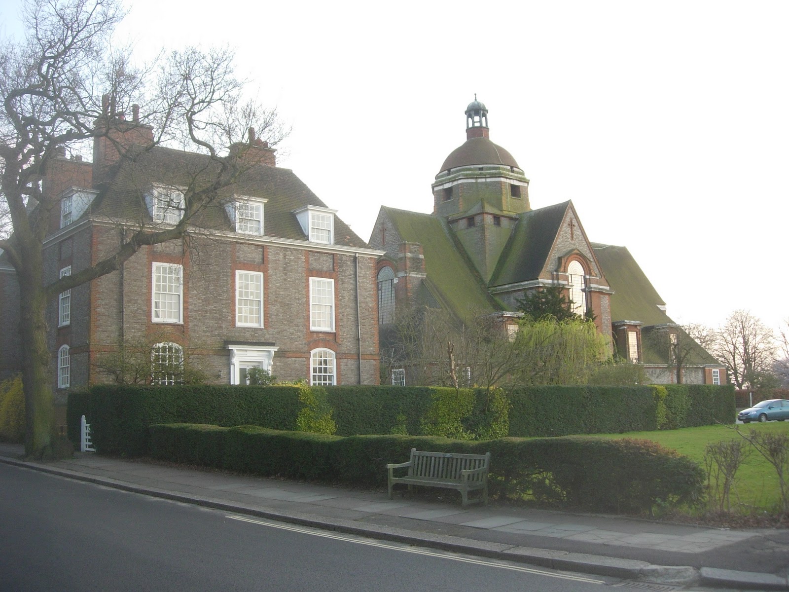
The idea of the neighbourhood is valid, with it’s 3 qualities, as I have outlined above, and  can be achieved with a majority of the dwellings consisting of houses with gardens. This has been proven to work, for instance, by the British  Garden City Movement. I recently gave an example, namely Hampstead Garden Suburb. This has the  quality of a village with a railway station at the centre.
 
It could be argued that the present Government needs a specifically conservative approach to this, in the sense that it is  something generated by private money rather than public money. To achieve this I would say firstly, that ideally an important step would be getting developers interested in the vitally important principle of mixed –use. Rather than building mono-functional zones such as out-of-town shopping centres and business parks, they should be encouraged to embrace mixed-use, both as buildings and neighbourhoods. This can be profitable as well as attractive. Instead of the approach of the single-story shopping shed surrounded by a car park you can have a multi-story building with shops on the ground floor and flats or offices above. This obviates the need for a enormous car park and if it is integrated into it’s neighbourhood, means that there will be houses with gardens within walking distance. All these activities can feed off each other, generating profits , with beautiful squares and landscaped streets instead of over-scaled vehicle parking.
 
As well as persuading developers of the benefits of mixed-use, we need to rethink attitudes to transport. David Cameron has said that he wants the present government to be the greenest ever. The initiative of the feed-in tariff was a good policy. It means that people can install photo-voltaic panels on their roof and sell the surplus electricity back to grid, meaning that the initial investment can be paid for in a much shorter period of time. However, finding a sustainable approach to transport is going to be much, much more difficult. Although we live in an age of diminishing oil resources, I personally doubt whether the electric car, which some people put their faith in, really is the answer. At present, they take 5 hours to recharge and have a range of 100 miles. I also doubt if the car powered on bio-fuels in the answer since their production depends on turning valuable farming land away from food production. What is necessary is to re-invent the notion of public transport. You may argue that this is socialist, because collective, rather than individual and conservative, but I am not sure I would agree. We already pay for roads collectively through our taxes so perhaps a proportion of this money should be  spent every year on public transport. All the roads we have paid for and built will arguably be empty in a few years time so perhaps we need to start modifying them for new types of transport i.e. trams can be retrofitted to existing road infrastructure. All this can be payed for by tax contributions and private developers through thinks like Section 106 agreements ( unfortunately these will be abolished under the NPPF). It is obviously easier to link up a tram to a constant power source than a car i.e. an overhead cable rather than a battery which goes flat every five  hours. The electricity can come from renewables i.e. solar, wind, ground source heat pump, CHP, biomass even nuclear. This entire approach will entirely change the look and feel of our towns and cities, reducing sprawl (which is often caused by cars) and leading to mixed-use neighbourhoods. This approach need not be excessively dense, as the example of the garden city movement shows.
 
Coming back to Harold Macmillan, we should really reflect on what planning policies he implemented in the 1950s and 1960s. He did  not simply advocate the relaxation of planning in favour of a developer’s free-for-all. The housing targets he set and met  were placed within the context of the planning policies of the day, policies evolved by figures such as Patrick Abercrombie and Frederic Osborne, both of whom were among the most gifted planners this country has ever produced. They were responsible for policies which included the New Towns, Green Belts and inner-city renewal. Looking back on this now, with over 50 years of reflection to draw on, it is clear that not all of these policies were unqualified successes.  Inner-city renewal often took the form of demolishing housing considered unsalvageable because  of sub-standard quality or because of war damage, and replacing it with concrete high-rises. Not all this housing is as bad as is now often supposed. Some of it was actually quite good. The high-rises, from the gleaming white concrete of early modernism to the grey concrete of the Brutalist era, were a mixed blessing, ranging in quality from good to awful. Some have called for them to be demolished and sometimes this approach has been adopted. However, it is noticeable that no one has called for the New Towns to be demolished and examples of this genre, such as  Harlow and Bracknell, are still viewed as attractive places to live. No one as far as I can see, wants to see the Green Belts built on. Hence we can still look back on the Macmillan era as a time when planning was approached responsibly and from which we can still draw relevant lessons today.

A responsible approach to urban design needs to be aware of the two scales at which towns and cities are experienced. I have already discussed the first scale, that of the neighbourhood. The next scale is that of the overall city i.e. a polycentric cluster of neighbourhoods. Urban life can, of course, be exciting, with all the facilities we associate with city life. Its drawback can be that it is actually too stimulating. People feel permanently exhausted, trapped as they are in built-up environment, cut off from nature. This can be mediated by building city neighbourhoods with a high proportion of the dwellings composed of houses with gardens. Another form of mediation is to deliberately limit a city’s size. This can be done by creating satellite towns. This was the idea behind the New Towns of  Macmillan’s time and indeed the Eco Towns policy, proposed in the last days of the Labour Government.

Many have voiced fears of a planning free-for-all and indeed it seems that under the draft National Planning Policy Framework, local authorities who do not have a core strategy in place by April 1st 2012 will be able to exercise no control over development in their area. It often seems that all planning policy in this country is directed by developers, nimbys, the heritage lobby and organisations such as the Campaign to Protect Rural England. All these groups sometimes pursue irreconcilable goals; this state of affairs will only get worse if there is not a proper planning policy to reconcile the wishes of all the various groups. Rarely is there a planning policy aimed at meeting the needs of all the British People. Many fear that the  effect of the NPPF, if it goes through, will produce very poor quality development which will not meet their housing needs or other building needs.

Tuesday 1 November 2011

The British Garden City Movement: Hampstead Garden Suburb

When trying to describe a specifically British type of urban design, some people fall into the error of recommending the British Garden City Movement justifying their argument on the reason that suburbia, they say,  is basically what British people want. The British Garden City Movement was one of the most remarkable urban design movements this country has ever produced. But it had nothing whatsoever to do with suburbia.

In order to justify that statement, I have chosen to look at an example of the Garden City Movement from 1909, Hampstead Garden Suburb. It is true that the typology of the house with garden is still relevant. However, I would argue that there at least three basic ideas that distinguish a Garden City from conventional suburbia:

Firstly, although both contain houses with gardens, A Garden City will also contain places for work, education, worship, shopping etc. In short, although a Garden City will try to create quieter, residential areas, it will also try to embrace the principle of mixed-use. It is worth remembering that the Garden City movement took place at time before mass-car ownership ( although it did take place during the age of the railways; all of the original garden cities have railway stations at the centre i.e. Letchworth, Welwyn, Hampstead and Bedford Park.) Modern development which includes out-of-town shopping centres plus suburbia cannot be considered an equivalent because a genuine garden city would contain shops within walking distances of residential buildings.

Secondly, in order to maintain a balance between built-up space and green space, a balance vital for health  and happiness,  a Garden City can only be allowed to reach a certain size, at which point a new Garden City must be started elsewhere. The ideal size  is based on a module of a neighbourhood or pedestrian-shed. One such module is a village really; how many such modules can be allowed to accumulate before a new city must be founded? Ebenezaar Howard  considered that the population of a garden city should be 32,000. According to the Rogers-led Urban Task Force the number of people necessary to support a hub of local services is 7500. So according to Ebenezar Howard’s approach, a garden city will contain about 4 neighbourhoods or pedestrian sheds. The illustrations to “Garden Cities of tomorrow”  don’t seem to bear this out but these  were only meant to be diagramatic.

The third principle is green belts, which define the edge of the city, maintaining a proper relationship between town and country. Strong planning controls would be necessary to prevent people building on them. Ebenezer Howard’s original proposals  allowed various activities on the green belt such as convalescent homes and agriculture; he envisaged them as growing their own food. A public transport infrastructure was provided though these were the days before mass car ownership and its attendant congestion had become a real problem.


This vision was realised at Hampstead Garden Suburb and indeed a host of other lessons can be drawn from this example as well. If one was going to learn lessons from this, one might as well be honest and admit that the some of the original principals have  been eradicated. Features such as a green belt and finite size were part of the original design but  are no longer there. The relentless growth of London meant this satellite was absorbed into Greater London.

One key  quality has been conspicuously retained, that of a mixed-use neighbourhood. Within a walkable-scaled area you will find housing, shopping, education and places of worship. What other qualities have been achieved? As a way of answering that question, perhaps the best method would be to walk the reader through a sequence of spaces, starting with what was conceived as the gateway to the entire project, the following buildings at the North of the site, at the junction of Finchley Road and Bridge Lane/ Temple Fortune Lane.


One of the eternal rules of good urban design seems to be that density can be increased where there is access to good public transport. Strangely, this rule is broken here. The high density part of the development is placed at the opposite end to that where the tube station is, Golders Green tube station.  These buildings are consciously modelled on medieval examples but can be seen as exemplars of what is now taken as a commonplace of good urban design; mixed-use. These buildings contain shops at ground floor and flats above. One might contrast this with single storey shopping buildings, without a different use above, which might be taken as a leitmotiv of bad urban design. As well as a failure to adopt the mixed-use approach, another fault of this type of building is the lack of height and hence a failure to create a sense of enclosure in the external spaces.

Several types of external space have been created. The first might be taken as a busy road with activities for pedestrians at the bases of the buildings.


Quieter residential streets have been created.

One of the great types of space created in this example of the Garden City Movement, and indeed in most of them is the green set in the close. Here they vary:


From closes surrounded by large detached houses.


To those enclosed by smaller, it would seem terraced houses.

This type of housing is also found at the Central Square which forms the centre of the whole community. 


The main public  buildings here  are by Lutyens. Whilst many agree that neighbourhoods need a centre, opinions differ as to what this should consist of. Whilst some would like to see all types of communal buildings at the neighbourhood centre, others take a  different view. Some take the view that whilst communal buildings such as schools should be placed at the centre, shops should be placed on  arterial road on the neighbourhood periphery, where they can attract passing traffic. This does seem to be the approach taken at Hampstead where Henrietta Barnet, the client for the whole project,  took many of the strategic decisions. With true Victorian zeal, believed that alcoholic drinks were a form of wickedness. She would not allow pubs or even shops around the main town square. The result is  a square occupied by two churches and the Henrietta Barnett School for Girls.


This has recently been subject to an interesting extension by  Hopkins Architects.


Streets are aligned to frame the views of the main public buildings


Hampstead garden Suburb has lost its character as a village separate from London though part of its green belt was preserved as an extension to Hampstead Heath. It remains as  a good example of a neighbourhood. I would argue the generic neighbourhood has four qualities: mixed-use, pedestrian scale, access to public transport and public spaces of real quality. Hampstead Garden Suburb has these in spades.

( Thanks to HGS Trust for the map of Hampstead Garden Suburb and Simon Kennedy, architecturalphotographer, for the photo of the extension to Henrietta Barnett School © Simon Kennedy 2011).

Saturday 22 October 2011

London's Docklands continued.........

For another example of poor urban design in Docklands/ East London I would take this site from the south side of the Thames, on the Greenwich Peninsula. By the Blackwall Approach Road a large commercial  development has been designed and built in the form of a series of large retail sheds.

The public space in front of it is dismal, simply a large car park.


The space behind is worse, simply an access road. The retail buildings do not have any active frontage on this side. There is no public realm here, simply a pavement which is not enlivened by views into the shops or indeed any access to the shops.


But this is the side which faces onto the Millennium  Village, itself only the first of a whole series of housing developments planned for Greenwich Peninsula. Effectively, these shops, which include a well known Sainsburys designed by Chetwood Associates, are surely destined to be Greenwich Peninsula High Street. But there is no quality of public space linking these sites; the retail developments are orientated the wrong way. In urbanistic terms,  the result is a disjointed mess. 

Here is the view looking from the Millennium  Village back towards the retail development.


A photo from Google should help orientate the reader. The Millennium Village is top-left and the retail development bottom-right.
Why do planning disasters like this happen? It is my belief that poor quality urban design like this happens because of a failure to understand how cities grow. Surely Greenwich Peninsula should have been identified as an important brown-field site. The Jubilee Line was proposed in the early 1990’s with a tube station on the tip of Greenwich Peninsula. Doubtlessly it must have been obvious that this large brown-field site would now be re-developed? I am sure some sort of strategy was drawn up for Greenwich Peninsula.
 
New development should be  designed with a long-term strategy. The strategy must culminate in buildings accumulating to form a sense of fabric, defining quality public spaces. Perhaps it necessary to from a hierarchy of external spaces; high-quality spaces for pedestrian and secondary spaces for cars and deliveries.

Here I show  a sketch proposal indicating a better approach that could have been taken to the design of these retail units. Some sort of double-façade approach should have been taken, with active frontage both to the car park and also the space facing towards the Millennium Village. The more people-orientated space is actually the more important space.


Strategies are, of course, filled in very slowly. A density diagram alone  is inadequate as a strategy. The failure of the shopping centre to relate to the Millennium Village is a clear example of this. The sort of diagrams that need to be produced must indicate qualities such as active frontage and the relationship of built fabric to public space. Once such a diagram has been drawn up then each building can be filled in. It may be a slow process but ensures that messes like this don’t happen, inevitable when you pursue a planning free-for-all.

( Thanks to Google for aerial photo)

Sunday 16 October 2011

London’s Docklands: the biggest planning disaster in Europe?

London’s Docklands is possibly the biggest planning disaster in Europe. Take the following example: Consider the following series of photos, illustrating the experience of walking from Poplar into Canary Wharf. The sequence of spaces begins here, on Poplar High Street.


Attempting to walk into Canary Wharf, you use a pedestrian bridge, beginning your ascent here.


You use a pedestrian bridge to cross what is basically an arterial road.


This is what greets you on the other side;  not Canary Wharf but a wasteland.


A knowledgeable pedestrian may realise that there are high quality public spaces on the far side of these building but there is no implied route to get there. If you are prepared to wander through the wasteland, you may eventually find your way into Canary Wharf.

Why are these two public realms so disjointed? Part of the answer lies with  the very  busy road separating them, the A1261. Dealing with heavily used transport infrastructure is a problem which occurs again and again in urban design. However, I feel that there is a deliberate strategy here to separate the two areas, keeping the rich and the poor apart. New developments like Canary Wharf, it was argued, were part a regeneration strategy for East London, replacing the defunct docks. Actually it offers little for the indigenous inhabitants of East London. All  urban designers  view the creation of a street as the creation of a place. Is it possible to give the A1261 a sense of place?

Perhaps it would be illuminating to compare this new part of Docklands/East London  with another part of London. On Silvertown Way, near Canning Town Station, several new apartment buildings have been constructed. The building illustrated here, just visible at far right, is probably  not a master-piece of modern architecture. But between this building and Canning Town Station there are a series of fine-grained, walkable public spaces.


 Perhaps the successful urbanistic quality of these this building, as opposed to the previous example,  the spaces between Poplar and Canary Wharf, can be summed up in the following diagram.


Here we have ultimately the reason why so much of London’s Docklands is a failure. There is no attempt to integrate new development i.e. what is usually conceived of as part of Docklands with East London. In fact, I cannot  help feeling there is a deliberate strategy to keep them apart. East London contains some of London’s poorest boroughs. The new docklands developments were intended for the well-off. The strategy seems to be islands of prosperity separated by wastelands from the deprived parts of East London. A pedestrian-hostile city where quality  of life is only available for those who can afford it.


 How can buildings accumulate to form a sense of urban fabric, defining public space instead of the disjointed mess we see here?  The building in Canning Town gives us a small clue. How do you make a place of a street which contains a high volume of fast traffic such as the A1261? There are many strategies which could be adopted. I suggest two examples.

                  The parkway    


                 The green bridge 


Thursday 6 October 2011

Fleet, Hampshire and Charleston, South Carolina, USA


What have these two places got in common, you may ask?
One is a good example  of a street which acts as a people orientated space; in the other such spaces are all too rare. However, moves are being made to create that sort of space.

The centre of Fleet is dominated by its vast “High Street,” Fleet Road, which  stretches approximately 1 km from Fleet Railway Station towards Church Crookham. Along that entire distance, buildings are brought up to back of pavement. No one has to walk from the pavement, across a vast  car park to get to a building. 


 When car-based urban design began to take hold, many developers began to demand enormous car-parking spaces at the front of their buildings. These might have attracted passing motorists but essentially destroyed the street as an urban space. The plan below  showing  the centre of Fleet is instructive. The space of Fleet Road is defined by shopping. Car parks are provided but they are set back from the shopping street. Passageways connect the shopping to the car parks, ensuring the latter are visually repressed.


In recent decades, urban design has seemed focused on creating spaces entirely for cars not people. This is as true of Britain as it is in the USA. My last two images are from the City of Charleston, South Carolina where car based urbanism has produced what can only be described as wastelands, spaces devoid of any human or aesthetic quality.


This is what is  proposed as a replacement. Streets, framed by the architecture which surrounds them. As the plan in this example seems to indicate, the car parks, an inevitable accompaniment to any retail development , are tucked away to avoid visual  disruption. There also seems to be some housing, in walking distance of the shops. It  is implied that the site of the second series of photos is show in the first set  i.e. they are remodelling the spaces.


If the British Public demanded from their retailers high quality urban design instead of simply convenient car parking, then the quality of British urban design might improve.

Ask yourself what British spaces resemble the first  set of example from  Charleston, South Carolina. Then ask yourself why more spaces cannot be remodelled to resemble the second.

Tuesday 4 October 2011

Two Business Parks in Frimley, Surrey

It is instructive to compare these two business parks in Frimley. One difference that is immediately apparent is that one is accessible by foot and that the other is not. In one it is possible to walk into the centre of Frimley, in the other it is not. One can be accessed by public transport. In the other, this does not seem possible.

The first is owned by Siemens Electronics. The road outside has footpaths allowing someone to walk into Frimley in about ten minutes.


The second business park is by the M3 exit.

The site is surrounded by motorway slip roads. This means they have no footpaths and hence no pedestrian access is possible to anywhere.
It might have been possible to arrange access via the side of the site which is not dominated by the Motorway. This side faces onto Hawley, which is a highly residential area and, in truth, contains few facilities office workers would wish to walk to.


Some of the buildings here are actually architecturally better looking than those at the first business park.


But here we have a group of buildings with no real mixture of uses, inaccessible by pedestrians and which seems to have no connection to public transport. All this is highly unsustainable. Ideally the office workers ought to be able to walk to Frimley, with all it’s facilities such as restaurants, sandwich shops and railway station.

The final irony is the pedestrian bridge connecting two of the buildings. It’s a beautiful bridge but unfortunately in the wrong place. The road it crosses has a negligible traffic. It would have been so much better if it had crossed one of the busy roads surrounding this site, allowing access to local neighbourhoods.


A case of non-joined up thinking.


Thursday 29 September 2011

Portsmouth and Woking: High-rises and Public Space

A comparison of two urban spaces, one  very successful and one less so.

Colin Rowe’s theoretical studies of urban design issues dealt with many issues, one of which was the relationship of tall buildings to public spaces. The role of the skyscraper can be seen as analogous to that of church spires in previous times: they provide a visual focus for the community and hence the design of public spaces around them must be considered in terms of how the public spaces and high-rise relate to each other.

A good example of this would be the two high-rises at Gunwharf Quarys in Portsmouth, Hampshire. The two towers, the Spinnaker Tower and Tower No. 1 also known as the Lipstick Tower were apparently inspired by the two main sources of power for driving ships: wind power and steam power. More to the point, there is clearly a thought-out relationship between the high-rises and the public spaces around them.


This is more than can be said for the centre of Woking in Surrey. At the Centre of the Town there is a square intended to be the social focus of the town. It contains entrances to the Library, the Civic Offices, the Peacocks Shopping Centre, the Town’s theatres and cinemas and the splendid red-brick Anglican church, ChristChurch. However, looming over the entire space is the presence of a concrete high-rise. The relationship of the high-rise and the square has not been thought out at all.

The centre of Woking is clearly undergoing a transformation. A sort of glass-circus feature is being constructed. It may improve the quality of the square but does not really address the issue of the relationship of the high-rise to the square.


The Peacocks Shopping Centre used to have a tower, on that was demolished to make way for the new development. It was refreshing to see a tower clearly designed in relation to the space it addressed.


 ( Photograph of Woking before alteration © Ron Strutt 2005 )

Thursday 22 September 2011

Towards an urbanism


The  purpose of this blog  is to find an approach to urbanism appropriate to the British Context. If that is it’s purpose then  it seems to me the following question must be answered; is urban design theory applicable to all cities or is an approach to urban design appropriate for one city irrelevant to other cities? Does a British city entail a specific cultural condition? For instance, the “Urban Renaissance” applied to British Cities during the premiership of Tony Blair seemed to often consist of building high-density housing in almost every available site in the country. Is this approach to urban design appropriate for a British Context?

If I had to choose one architectural theorist who understood regional architectural cultures I would choose Christian Norberg-Schulz. No-one more clearly perceived the difference between cities in the North and South of Europe. Norburg-Schulz believed that there are basically two types of architectural culture that exist in Europe, one of the North and one of the South or, as he would put it, Nordic and Mediterranean Europe. He argued that in an urban condition, the ceiling is effectively the sky but it’s appearance is conditioned by the upper termination of the buildings. In the North, the sky is the result of “variable atmospheric conditions;” in the South, the sky is perceived as “a distant and stable background.” Hence, these two conditions can be seen to giving rise to what might be taken as two typologies, two forms which capture the essence of their respective architectural cultures: the gable in the North and the dome in the South.

 The difference between Nordic and Mediterranean architecture could also be understood by looking at the predominant materials used, timber in the North of Europe and Stone in the South,  in what might be taken as the formative period in these civilizations which would be the Medieval period in Northern Europe and Classical period in Southern Europe. There are of course exceptions to this rule but, in the case of Northern Europe, timber can be taken as a defining “image.” Norberg-Schulz states that


 “These images may be related to the fact that in the North vegetation forms the continuous “ground” on which rocks and mountains appear. In the arid South, instead, the topographical configurations constitute the background, whereas trees and groves are perceived as relatively isolated “figures.” Existentially it is therefore justifiable to talk about wood and stone cultures.”

From this we can deduce that the two types of architectural culture in Europe, one of the North and one of the South or as Norburg-Schulz would say, the Nordic and the Mediterranean, do not follow from tradition but rather they follow from nature. It also follows that there are two types of city. We can examine these two types of city to develop an appropriate idea about architectural strategy, using the idea that a strategies gestalt is generated from the interaction of figure and ground.  Norberg-Schulz argues that, in a Mediterranean city the ground, on which the figure appears, consists of “ topographical configurations” which often mean mountains and stone. The figure will consist of urban spaces and buildings, often themselves of stone. Mediterranean people, drawing on their experience of nature, already expect a stone environment and do not need a large amount of greenery in a city. Hence there will be little in the way of parks and gardens. In a Northern environment the “ground” consisits of trees and greenery.  A large amount  of land used as parks and gardens will not be perceived as wasteful use of space but simply a “ground” on which figures appear usually in the form of buildings or urban planning exercises. Hence strategic ideas appropriate to a Mediterranean city cannot be simply transposed to a British city and be found to work.

So am I advocating a return to suburbanism?

In order to answer that, firstly it is necessary to define what is meant by suburbanism. Many people use that word, thinking they defined something with a great deal of precision. They have not. When many people use that word, they often mean houses with gardens. Hence, if you are trying to create  an urban design proposal, the word suburbanism is essentially useless. Urban design proposals deal with all the functions of a town or city, not just one i.e. housing. Le Corbusier, when he drew up some of his famous city plans, at times definitely indulged in megalomania. But he did assign four functions to his city plans not one.

There is another way of defining suburbia as opposed to a truly urban condition. In an urban condition  buildings are brought  up to back of pavement. In a suburban condition buildings are set back allowing front gardens. But there are plenty of exceptions to this. This definition can be broken down.

So what kind of urbanism am I advocating?

The aim of this blog is an attempt to answer that question.


( Quotation of  Christian Norberg-Schulz from  “Architecture: Meaning and Place-“Timber buildings in Europe”“     
Rizzoli, New York, 1988.)