Showing posts with label Places. Show all posts

Sunday, 4 May 2014

The British Garden City Movement: Bedford Park


Jane Jacobs attacked the Garden City movement when she stated that “its prescription for saving the city was to do the city in.” Was this criticism justified? Well, the answer is surely yes and no. Firstly, the original Garden City movement was an attempt to deal  with the growth of existing cities by proposing satellite communities. The size of existing cities would be limited by green belts. These would help  define a city’s  size, maintain a balance between city and country and by forcing new developments into existing sites in a city  act as a catalyst for urban regeneration.

The idea of satellites was basically an offshoot of its concern about  the issue of city size. Bedford Park, in west London, is often taken as a good example of the Garden City Movement though its proximity to central London ensures it should really be viewed as a neighbourhood of an existing city rather than a true satellite.
An important fact about Bedford Park is the date of its founding, 1875, which gives it some claim to be the origin of the Garden City Movement.

The development is often viewed as the work of Richard Norman Shaw although Shaw was actually the second architect to be appointed by the client, Jonathan Carr. Other architects who worked on the development included Edward W Godwin, Maurice Adams and EJ May.


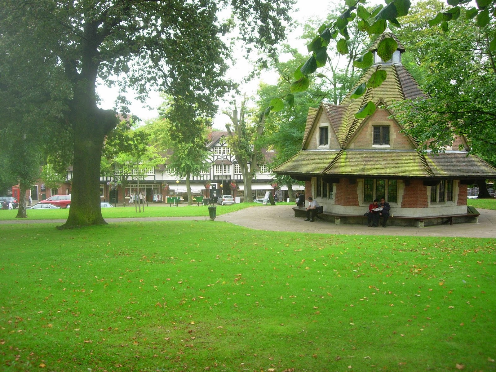
The development is centred around Acton Green Common and the adjacent Turnham Green  tube station. Here are the non-residential uses such as parade of shops, church and pub. 


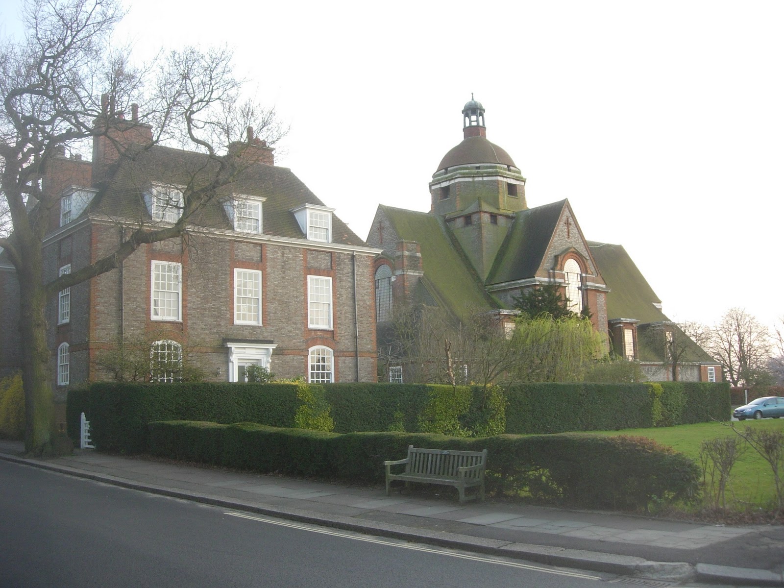
Shaw was  responsible for buildings which compromise centre pieces of the development such as St Michael &  All Angels Church  and  the Tabard Pub.


                                     Shops on The South Parade.

A series of residential streets fan out from this heart of the community.
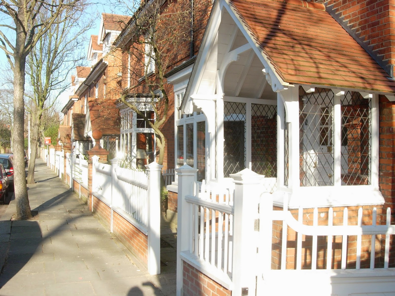


                                                     Priory Gardens


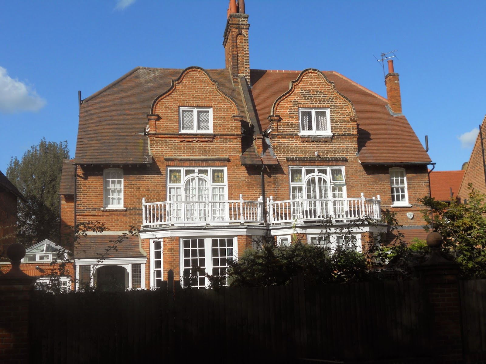
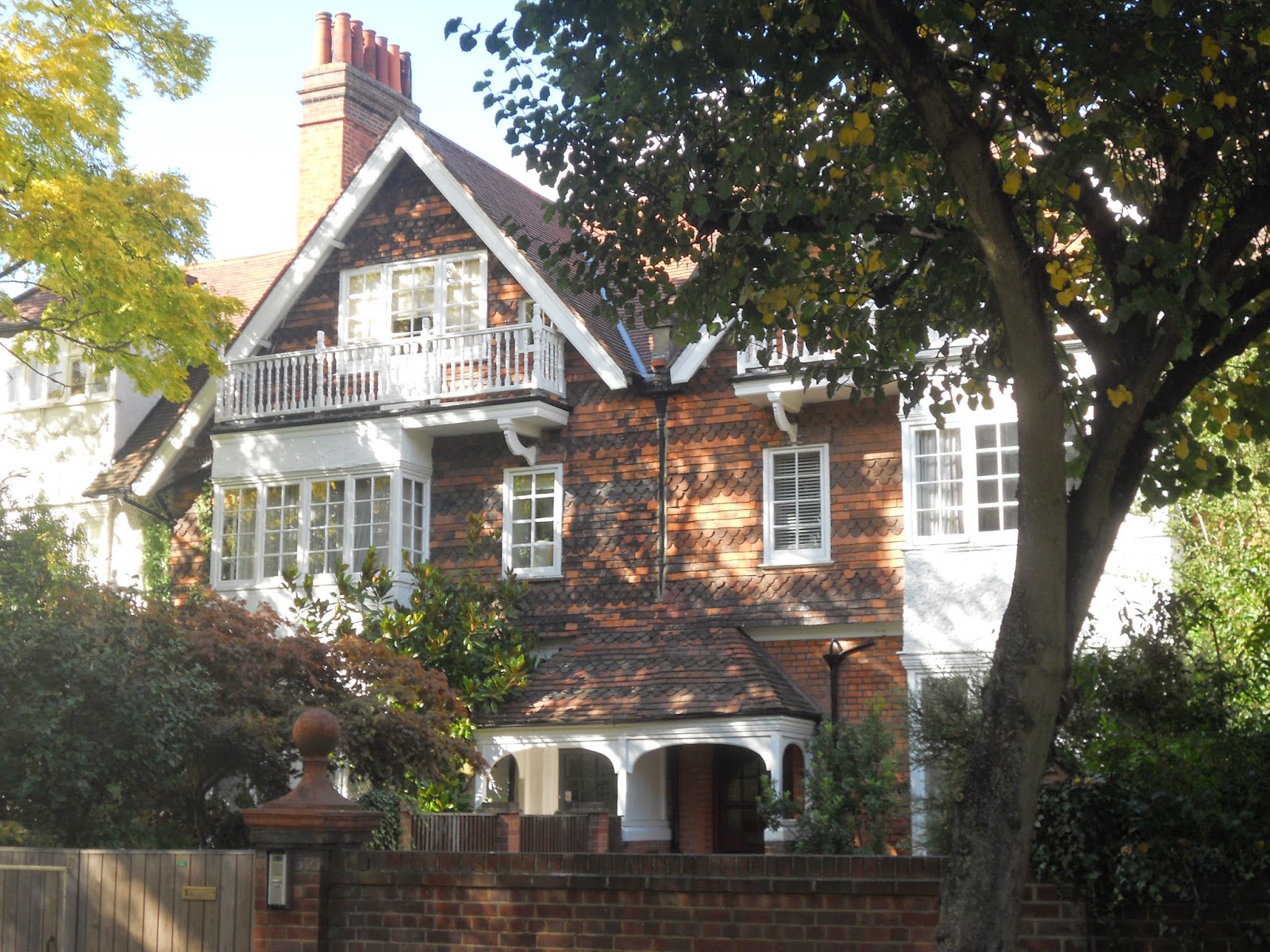
The houses by Shaw at 22 Woodstock Road  are surprisingly not the best in the development.


High density housing has been allowed on part of the site.

Richard Norman Shaw is remembered as one of the most eclectic architects of the Nineteenth Century, responsible for buildings such as New Scotland Yard  on the Thames Embankment and the less interesting Piccadilly  Hotel.

Much of the development has been designed in what became known as The Queen Anne Style.   It is something of a historical curiosity that Richard Norman Shaw, a   half-Irish, half-Scottish architect should devote his career to this English, or to be more precise, Dutch style of architecture.

Dutch motifs such as bell gables can be found throughout the development. Many of these houses are not actually by Shaw himself.


Should this approach be regarded  as something simply producing surface effects rather than any deeper, spatial qualities, the sort of criticism sometimes leveled at the  work of John Nash? Well, to give an informed answer to that question I would have to have seen more Shaw interiors and I can only recall visiting the interior of two buildings by  Shaw ,  Swan House on Chelsea Embankment and The Royal Geographical Society in South Kensington and  both indeed provided a memorable experience.


At any rate, the development contains some of the prettiest houses in London.


The development has provided a home for famous residents such as W.B. Yeats, Camille Pissarro and, in more recent years, John Humphrys of the  BBC. It also appeared in the  G.K. Chesterton novel The Man who was Thursday under the name Saffron Park.

It is true that the garden City movement as conceived by Ebenezer Howard had little to say about existing cities and hence offers little guidance on issues such as the regeneration of inner-city  sites. It that sense, it cannot be said to be a comprehensive theory of urban design. Its concern for issues such as city size and satellites did evince an ability  to think in regions, something often sadly amiss from today’s thinking on urban design.

Wednesday, 9 April 2014

Flickr Has Arrived


I have done what I have intended to do for some time; start uploading some of my large photo archive to Flickr.

A few years ago I was lucky enough to visit Copenhagen so this is my first set of photographs.


Tuesday, 25 March 2014

Bournville: an example of business-led urban design.


If I keep adding posts dealing with The Garden City Movement I fear  I will start repeating myself at least as far as the writing goes. Nevertheless even a generic form can allow for  fascinating, infinite  variations, providing lessons which are eternally relevant. For this reason I am posting a piece on Bournville, Birmingham’s great example of The Garden City Movement. This can be seen as a photo essay with perhaps similar postings to come.


                                               Typical semi-detached housing


Bournville was created by  George and Richard  Cadbury  who wished to relocate their chocolate factory from a cramped, city centre site to a location more amenable to expansion. They chose a site four miles from the centre of Birmingham well connected by the new railways and canals, close by the Bourn Brook.
The original move took place in 1879. In 1893, 120 acres of land was purchased to create a model village. By 1900, 313 cottages and houses had been built, at which stage ownership passed to the Bournville Village Trust.


                                 Shops with other uses above by the village green


                                                    Bournville Rest House


                                                     Bournville Primary School


                                               Bournville Center for Visual Arts

A factor of urban design which must always be considered in, of course, the economics of a  creation of a  proposal. We live in an age of small government whose most overriding concern often seems to be  shifting financial responsibility away from the public to the private. It is heartening to see a business-led development of such high quality. Businesses should take note that there are a huge number of benefits entailed when a development like this is undertaken. Firstly, naming a town after a company’s product generates a massive amount of favourable publicity for a company. Why, indeed, should the provision of things such as affordable housing and good schools be left to the government? Businesses with access to good financial resources should realise that provision for staff goes way beyond mere wages. Businesses which find it difficult to recruit high-quality staff could look at Bournville and see what is being offered here. I hesitate to use a word as  repellent as “lifestyle” and would rather focus on essential matters such as affordable housing and good schools.


                                                                    Map


                               Cadbury Factory with cricket pitch in the foreground


                                                                 Church


I think it clear that my photos convey what a remarkable achievement Bournville is. It has, as I never tire of saying, the four qualities that really make a neighbourhood; access to public transport, a walkable scale, a mixture of uses and public spaces of real quality.


Tuesday, 1 November 2011

The British Garden City Movement: Hampstead Garden Suburb

When trying to describe a specifically British type of urban design, some people fall into the error of recommending the British Garden City Movement justifying their argument on the reason that suburbia, they say,  is basically what British people want. The British Garden City Movement was one of the most remarkable urban design movements this country has ever produced. But it had nothing whatsoever to do with suburbia.

In order to justify that statement, I have chosen to look at an example of the Garden City Movement from 1909, Hampstead Garden Suburb. It is true that the typology of the house with garden is still relevant. However, I would argue that there at least three basic ideas that distinguish a Garden City from conventional suburbia:

Firstly, although both contain houses with gardens, A Garden City will also contain places for work, education, worship, shopping etc. In short, although a Garden City will try to create quieter, residential areas, it will also try to embrace the principle of mixed-use. It is worth remembering that the Garden City movement took place at time before mass-car ownership ( although it did take place during the age of the railways; all of the original garden cities have railway stations at the centre i.e. Letchworth, Welwyn, Hampstead and Bedford Park.) Modern development which includes out-of-town shopping centres plus suburbia cannot be considered an equivalent because a genuine garden city would contain shops within walking distances of residential buildings.

Secondly, in order to maintain a balance between built-up space and green space, a balance vital for health  and happiness,  a Garden City can only be allowed to reach a certain size, at which point a new Garden City must be started elsewhere. The ideal size  is based on a module of a neighbourhood or pedestrian-shed. One such module is a village really; how many such modules can be allowed to accumulate before a new city must be founded? Ebenezaar Howard  considered that the population of a garden city should be 32,000. According to the Rogers-led Urban Task Force the number of people necessary to support a hub of local services is 7500. So according to Ebenezar Howard’s approach, a garden city will contain about 4 neighbourhoods or pedestrian sheds. The illustrations to “Garden Cities of tomorrow”  don’t seem to bear this out but these  were only meant to be diagramatic.

The third principle is green belts, which define the edge of the city, maintaining a proper relationship between town and country. Strong planning controls would be necessary to prevent people building on them. Ebenezer Howard’s original proposals  allowed various activities on the green belt such as convalescent homes and agriculture; he envisaged them as growing their own food. A public transport infrastructure was provided though these were the days before mass car ownership and its attendant congestion had become a real problem.


This vision was realised at Hampstead Garden Suburb and indeed a host of other lessons can be drawn from this example as well. If one was going to learn lessons from this, one might as well be honest and admit that the some of the original principals have  been eradicated. Features such as a green belt and finite size were part of the original design but  are no longer there. The relentless growth of London meant this satellite was absorbed into Greater London.

One key  quality has been conspicuously retained, that of a mixed-use neighbourhood. Within a walkable-scaled area you will find housing, shopping, education and places of worship. What other qualities have been achieved? As a way of answering that question, perhaps the best method would be to walk the reader through a sequence of spaces, starting with what was conceived as the gateway to the entire project, the following buildings at the North of the site, at the junction of Finchley Road and Bridge Lane/ Temple Fortune Lane.


One of the eternal rules of good urban design seems to be that density can be increased where there is access to good public transport. Strangely, this rule is broken here. The high density part of the development is placed at the opposite end to that where the tube station is, Golders Green tube station.  These buildings are consciously modelled on medieval examples but can be seen as exemplars of what is now taken as a commonplace of good urban design; mixed-use. These buildings contain shops at ground floor and flats above. One might contrast this with single storey shopping buildings, without a different use above, which might be taken as a leitmotiv of bad urban design. As well as a failure to adopt the mixed-use approach, another fault of this type of building is the lack of height and hence a failure to create a sense of enclosure in the external spaces.

Several types of external space have been created. The first might be taken as a busy road with activities for pedestrians at the bases of the buildings.


Quieter residential streets have been created.

One of the great types of space created in this example of the Garden City Movement, and indeed in most of them is the green set in the close. Here they vary:


From closes surrounded by large detached houses.


To those enclosed by smaller, it would seem terraced houses.

This type of housing is also found at the Central Square which forms the centre of the whole community. 


The main public  buildings here  are by Lutyens. Whilst many agree that neighbourhoods need a centre, opinions differ as to what this should consist of. Whilst some would like to see all types of communal buildings at the neighbourhood centre, others take a  different view. Some take the view that whilst communal buildings such as schools should be placed at the centre, shops should be placed on  arterial road on the neighbourhood periphery, where they can attract passing traffic. This does seem to be the approach taken at Hampstead where Henrietta Barnet, the client for the whole project,  took many of the strategic decisions. With true Victorian zeal, believed that alcoholic drinks were a form of wickedness. She would not allow pubs or even shops around the main town square. The result is  a square occupied by two churches and the Henrietta Barnett School for Girls.


This has recently been subject to an interesting extension by  Hopkins Architects.


Streets are aligned to frame the views of the main public buildings


Hampstead garden Suburb has lost its character as a village separate from London though part of its green belt was preserved as an extension to Hampstead Heath. It remains as  a good example of a neighbourhood. I would argue the generic neighbourhood has four qualities: mixed-use, pedestrian scale, access to public transport and public spaces of real quality. Hampstead Garden Suburb has these in spades.

( Thanks to HGS Trust for the map of Hampstead Garden Suburb and Simon Kennedy, architecturalphotographer, for the photo of the extension to Henrietta Barnett School © Simon Kennedy 2011).

Saturday, 22 October 2011

London's Docklands continued.........

For another example of poor urban design in Docklands/ East London I would take this site from the south side of the Thames, on the Greenwich Peninsula. By the Blackwall Approach Road a large commercial  development has been designed and built in the form of a series of large retail sheds.

The public space in front of it is dismal, simply a large car park.


The space behind is worse, simply an access road. The retail buildings do not have any active frontage on this side. There is no public realm here, simply a pavement which is not enlivened by views into the shops or indeed any access to the shops.


But this is the side which faces onto the Millennium  Village, itself only the first of a whole series of housing developments planned for Greenwich Peninsula. Effectively, these shops, which include a well known Sainsburys designed by Chetwood Associates, are surely destined to be Greenwich Peninsula High Street. But there is no quality of public space linking these sites; the retail developments are orientated the wrong way. In urbanistic terms,  the result is a disjointed mess. 

Here is the view looking from the Millennium  Village back towards the retail development.


A photo from Google should help orientate the reader. The Millennium Village is top-left and the retail development bottom-right.
Why do planning disasters like this happen? It is my belief that poor quality urban design like this happens because of a failure to understand how cities grow. Surely Greenwich Peninsula should have been identified as an important brown-field site. The Jubilee Line was proposed in the early 1990’s with a tube station on the tip of Greenwich Peninsula. Doubtlessly it must have been obvious that this large brown-field site would now be re-developed? I am sure some sort of strategy was drawn up for Greenwich Peninsula.
 
New development should be  designed with a long-term strategy. The strategy must culminate in buildings accumulating to form a sense of fabric, defining quality public spaces. Perhaps it necessary to from a hierarchy of external spaces; high-quality spaces for pedestrian and secondary spaces for cars and deliveries.

Here I show  a sketch proposal indicating a better approach that could have been taken to the design of these retail units. Some sort of double-façade approach should have been taken, with active frontage both to the car park and also the space facing towards the Millennium Village. The more people-orientated space is actually the more important space.


Strategies are, of course, filled in very slowly. A density diagram alone  is inadequate as a strategy. The failure of the shopping centre to relate to the Millennium Village is a clear example of this. The sort of diagrams that need to be produced must indicate qualities such as active frontage and the relationship of built fabric to public space. Once such a diagram has been drawn up then each building can be filled in. It may be a slow process but ensures that messes like this don’t happen, inevitable when you pursue a planning free-for-all.

( Thanks to Google for aerial photo)

Sunday, 16 October 2011

London’s Docklands: the biggest planning disaster in Europe?

London’s Docklands is possibly the biggest planning disaster in Europe. Take the following example: Consider the following series of photos, illustrating the experience of walking from Poplar into Canary Wharf. The sequence of spaces begins here, on Poplar High Street.


Attempting to walk into Canary Wharf, you use a pedestrian bridge, beginning your ascent here.


You use a pedestrian bridge to cross what is basically an arterial road.


This is what greets you on the other side;  not Canary Wharf but a wasteland.


A knowledgeable pedestrian may realise that there are high quality public spaces on the far side of these building but there is no implied route to get there. If you are prepared to wander through the wasteland, you may eventually find your way into Canary Wharf.

Why are these two public realms so disjointed? Part of the answer lies with  the very  busy road separating them, the A1261. Dealing with heavily used transport infrastructure is a problem which occurs again and again in urban design. However, I feel that there is a deliberate strategy here to separate the two areas, keeping the rich and the poor apart. New developments like Canary Wharf, it was argued, were part a regeneration strategy for East London, replacing the defunct docks. Actually it offers little for the indigenous inhabitants of East London. All  urban designers  view the creation of a street as the creation of a place. Is it possible to give the A1261 a sense of place?

Perhaps it would be illuminating to compare this new part of Docklands/East London  with another part of London. On Silvertown Way, near Canning Town Station, several new apartment buildings have been constructed. The building illustrated here, just visible at far right, is probably  not a master-piece of modern architecture. But between this building and Canning Town Station there are a series of fine-grained, walkable public spaces.


 Perhaps the successful urbanistic quality of these this building, as opposed to the previous example,  the spaces between Poplar and Canary Wharf, can be summed up in the following diagram.


Here we have ultimately the reason why so much of London’s Docklands is a failure. There is no attempt to integrate new development i.e. what is usually conceived of as part of Docklands with East London. In fact, I cannot  help feeling there is a deliberate strategy to keep them apart. East London contains some of London’s poorest boroughs. The new docklands developments were intended for the well-off. The strategy seems to be islands of prosperity separated by wastelands from the deprived parts of East London. A pedestrian-hostile city where quality  of life is only available for those who can afford it.


 How can buildings accumulate to form a sense of urban fabric, defining public space instead of the disjointed mess we see here?  The building in Canning Town gives us a small clue. How do you make a place of a street which contains a high volume of fast traffic such as the A1261? There are many strategies which could be adopted. I suggest two examples.

                  The parkway    


                 The green bridge